Spatiotemporal quantification of relative contributions of compound flood drivers using Shapley value-based approach
How the method works
Key findings
- 1The method accurately reproduces the compound water level from all four drivers, using every driver combination with non-uniform weights.
- 2For Hurricane Beryl (2024) in the Houston–Galveston region, Texas, it shows where and when each driver mattered, including where a driver lowered the water level by interacting with the others.
- 3A comparison with Hurricane Harvey (2017) shows that driver contributions differ between hurricanes, which can guide driver-specific flood mitigation.
Which flood driver raised the water, and where?
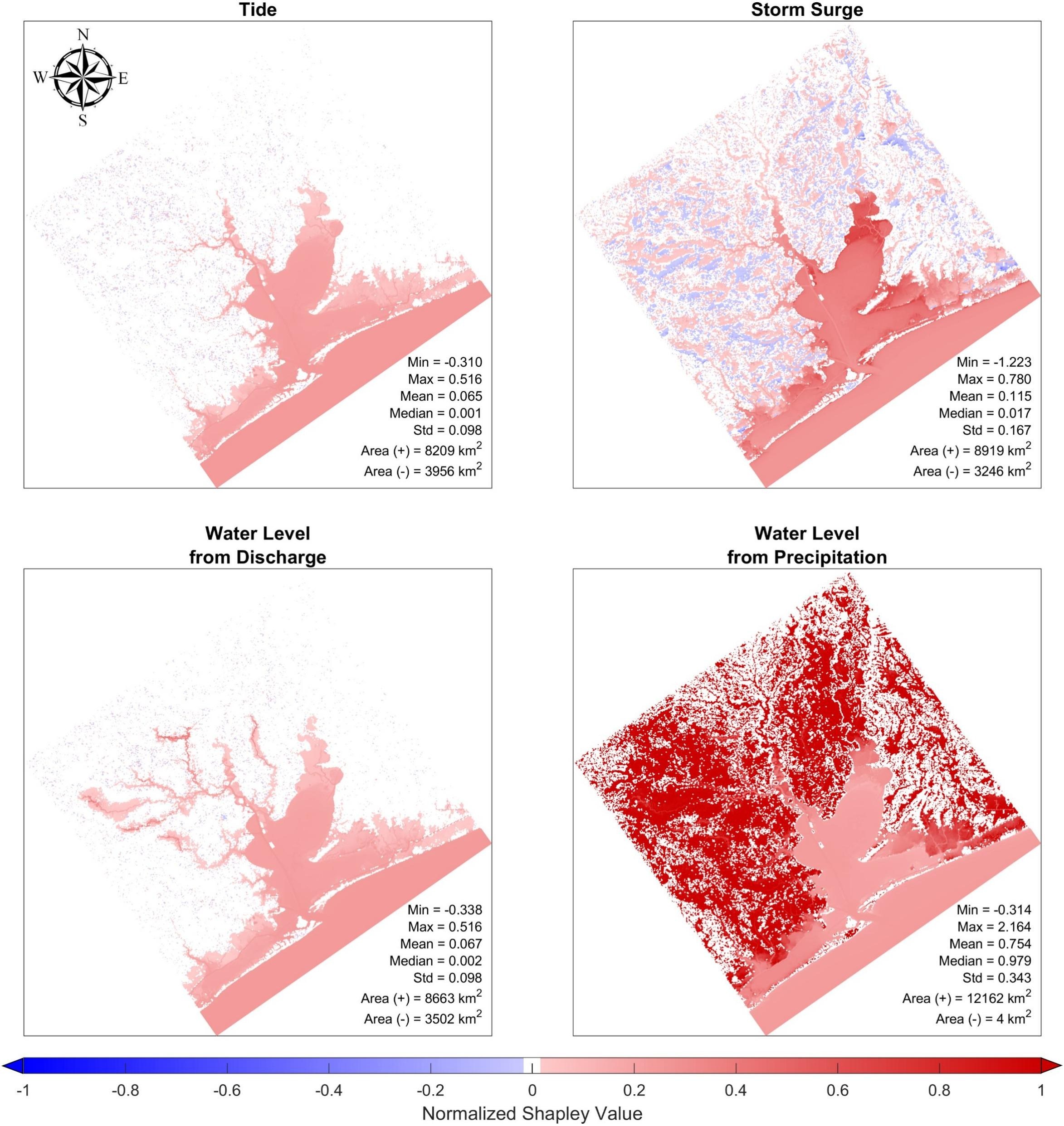
Reading the maps
The four maps show the Houston–Galveston region, Texas, 30 hours after Hurricane Harvey (2017) made landfall. Each map isolates one flood driver: tide, storm surge, river discharge (river flow), and precipitation (rainfall).
Color shows the driver’s normalized Shapley value: its contribution to the water level at each location, divided by the combined contribution of all four drivers there (1 means the driver alone equals that combined total). Blank cells have values between −0.001 and 0.001.
What it reveals
At this moment, rainfall dominates nearly all of the land (median value 0.979). Storm surge raises water mainly in Galveston Bay but lowers it in scattered inland areas. Tide and river discharge add smaller shares, mostly in the bay and along rivers.
Numbers on each map: the minimum (Min), maximum (Max), mean, median, and standard deviation (Std) of the values, plus the area where the driver’s effect was positive, Area (+), or negative, Area (−).
Read the full abstract
Understanding flood driver interactions is essential for assessing compound floods, as their nonlinear contributions largely determine flood severity. This requires quantifying the spatiotemporal contributions of each driver to the compound water level across all combinations. Although several mathematical approaches have been developed, none fully account for all possible driver combinations or accurately represent the proportional contribution of each driver to the compound water level. To address these limitations, we introduce a Shapley value-based approach to compute the relative contributions of four flood drivers: tide, storm surge, river discharge, and precipitation, simulating Hurricane Beryl (2024) in the Houston–Galveston region, Texas. The spatiotemporal analysis revealed how compound flooding changes across space and time, including instances where certain drivers contributed negatively (reduced the compound water level when considered nonlinearly along with other flood drivers) to the overall water level. The comparison with Hurricane Harvey confirmed the method’s ability to capture variations in flood driver contributions across different hurricanes. By incorporating all driver combinations with non-uniform weights, our method accurately reproduced the compound water levels, including all four flood drivers. Overall, this Shapley value-based approach provides new insights into the spatiotemporal dynamics of each flood driver’s contributions and has the potential to inform flood driver-specific, targeted mitigation and risk management strategies.